Google Partners With SDSU for 'Street View'
SDSU is the first university in the world to be included in the widely popular Google Maps feature.
From the historical Hepner Hall to the modern suspension bridge over College Avenue and everywhere in-between, panoramic views from anywhere on San Diego State University’s 281-acre campus are now available around the world, thanks to a unique partnership with Google.
SDSU the first to participate
SDSU is the first university in the world to participate in the Google Maps Street View Partner Program, which aims to provide interactive 360-degree ground-level photos of special attractions around the world.
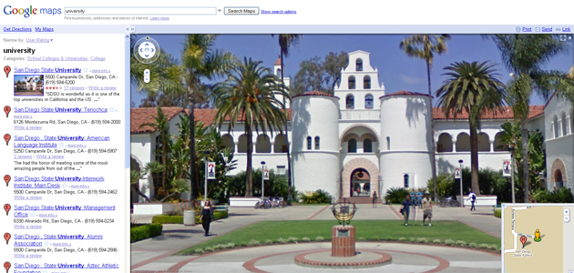
The Google Street View of SDSU is available here.
“We’re very excited to provide Street View imagery of SDSU,” said Dan Ratner, mechanical engineer for Street View at Google.
“Whether you’re a prospective student wanting to get a unique perspective of campus, an alumna wishing to take a stroll down memory lane, or a Google Maps user looking for new locations to explore, you’ll find this to be a great new addition to Google Maps.”
Many benefits to the campus community
SDSU officials said the Google partnership has many potential benefits.
“Google’s Street View of SDSU will be a great tool for students, parents and others who’d like to get a sense of the campus geography before coming here,” said Aaron Hoskins, manager of new media at SDSU.
“We also anticipate that a variety of other campus applications will emerge that take advantage of this tool.”
The photos used to produce the Street View map of SDSU were collected by Google in two days in April, using a tricycle specially modified to collect photos of pedestrian-only areas.
These “Google Trikes,” which weigh more than 300 pounds, are outfitted with a nine-camera apparatus used to collect the images that produce the 360-degree Street View maps. The trikes also use GPS units and 3-D laser scanners, which assure a comprehensive and efficient collection process.
About Google Street View
Google Street View launched in 2007 and has expanded to cover many of the biggest cities and rural areas in more than ten countries, including the United States, the United Kingdom, Japan and others.
Recently, Google Street View began using the “Trike” to gather imagery of pedestrian-only areas, such as SDSU and other universities that were previously inaccessible to the Street View vehicles used to collect photos of sites around the world. Google blurs photos of people so they cannot be identified in Google Street View photos.